

Batuan Sedimen
B atu terbuat dari biji-bijian. Setiap butir biasanya terbuat dari satu mineral. Batuan yang berbeda mengandung campuran mineral yang berbeda. Batu dapat dipecah oleh pelapukan kimia, pelapukan fisik atau pelapukan biologis. K etika batu sudah lapuk, potongan mungkin jatuh dari permukaan batu atau hanyut oleh air. Ini disebut erosi. Fragmen batuan (sedimen) ini dapat diangkut dengan memindahkan air, angin atau es. Ketika air atau angin melambat, atau es mencair, fragmen diendapkan sebagai lapisan sedimen. Selama periode waktu yan…

Memprediksi Cuaca
Picture by Gerd Altmann Orang selalu mencoba memprediksi cuaca karena berbagai alasan. Misalnya, prakiraan cuaca: - Sangat penting bagi orang yang bekerja di laut, seperti nelayan, pemilik feri, dan pekerja kilang minyak. - Penting bagi orang yang bekerja di luar atau di darat, seperti petani. - Berguna untuk anggota masyarakat umum. Beberapa ramalan cuaca bisa menjadi penting. Misalnya, para ilmuwan selalu bekerja dengan cara memprediksi kejadian cuaca yang serius seperti tornado dan angin topan. Jika publik diberi peringatan…

Volcanoes IGCSE
A volcano is a hole or crack in the ground through which gases, lava & rock are erupted. Types of volcanoes: 1. Composite Volcano -> The lava is viscous & slow. -> It flows not far away -> The volcano steep sided 2. Shield Volcano -> The lava is runny -> It flows far away -> The volcano is gentle sided Classification of Volcano 1. Active Volcano: Liable to erupted e.g. Mount Etna 2. Dormant (s…
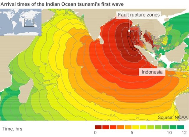
Case study { Indian Ocean Earthquake/South Asian Tsunami (LEDCs)
§ The ocean floor close to the Sumatra Island of Indonesia § 9.2 scale Richter. § The 2 nd highest ever record on a seismograph. § The earthquake was caused by the Indian Plate subducts underneath the Burma Plate along the deep Andaman-Sumatran Ocean Trench. § The rupture was the longest ever caused by an earthquake, 400 kilometer long and 100 kilometer wide. § The epicenters were 30 kilometer below seal levels. § The earthquake lasted for 8 minutes. § The waves effects South East Asia, India, Sri L…
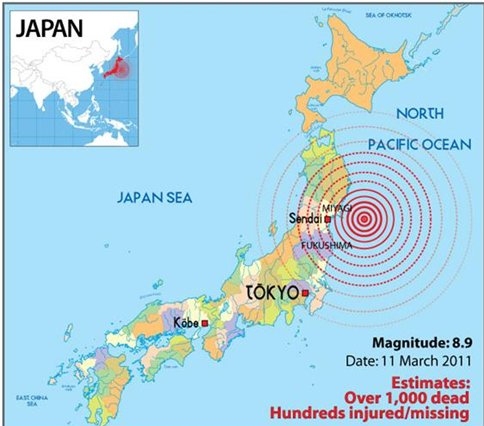
Case Study { The 2011 Tohoku, Sendai Earthquake In Japan }
§ Japan has many earthquakes in the past and the future. § They have earthquake signal in every places, such as school, offices and hospital. § There are substantial sea walls to defend against tsunami. § The coastline is particularly vulnerable to tsunami waves, because it has many deep bays that amplify the waves and cause the land to be inundated by the sea. § On 11 March 2011, a magnitude 9.0 earthquake occurred off the north-east of the main island, Honshu. § It happened because Pacifi…

The Eruption Of Mount Pinatubo {Geography, IGCSE}
Mount Pinatubo erupted in 15 June 1991 The second-largest volcanic eruption of the 20th century. A magnitude 7.8 scale richter hit Luzon Island. Mount Pinatubo in the Philippines is one of a chain of volcanoes forming the Luzon volcanic island arc. The second-largest eruption to affect a densely populated area. The arc parallels the West coast of Luzon and reflects the subduction zone along the Manila trench to the West. The steep, easterly dipping subduction of the Eurasian Plate started about 10 million years ago and produce a…
Connect